
By Derek Schlennstedt
One map to rule them all, one map to find them.
One map to bring them all, and in the Yarra Ranges bind them.
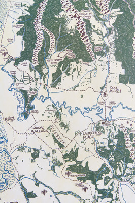
The map looks like something ripped from the pages of a Tolkien book: pyramidal mountains like sharp teeth, forests of glyph-like trees, hand-inked names and even a dragon or two.
But instead of Middle Earth, Brunswick cartographer Adam Mattinson is charting The Yarra Ranges shire, and it looks not unlike the shire from the Lord of The Rings.
Mr Mattinson creates in depth and complex maps and also likes Lord of The Rings. So, in August 2017 he decided to bring the two together.
“I’m definitely a fan of the Lord of The Rings and Tolkien’s books, and one of the things that captured my imagination reading them was the maps, so I thought I’d recreate that for our own little backyard,” he said.
“I grew up in Mount Evelyn, and went to school in Mount Evelyn, and I feel like the area and landscape of the region lends itself to the Lord of The Rings-esque map.”
Covering the entirety of the Yarra Ranges Shire, the map extends from Marysville all the way down to Ferntree Gully and across to Gembrook.
I Started drawing in my home town of Mount Evelyn, continued it out to Wandin and Seville, and Lilydale, and because the shire is in the Lord of The Rings I thought I might as well include the entire Yarra Ranges Shire.
Having since moved to Brunswick, Mr Mattinson said making the map has brought back his love for the area.
“In making the map, you remember all these areas you visited as a kid.”
“Recently I’ve been working on things around The Patch and Macclesfield and it really is a nice area and rekindles that interest and love for the region.”
Each town, mountain range and lake is featured in the unique map and in Mr Mattinson’s world Puffing Billy is identified as a fire breathing dragon.
Although the map has been largely a personal endeavour, Mr Mattinson said he has enjoyed the interest it has garnered from locals and said he might sell some copies of the townships.
“It’s massive at its full size … two metres in length,” he said.
“When I’ve finished it, the firs thing is I’m going to put it up on my living room wall.”
“I didn’t start off with the idea of selling it but if it sparks that imagination within people and shared interest then that’s kind of a cool bonus.”
You can keep track of the map and its progress by visiting Mr Mattinson’s Facebook at “Adam Mattinson Maps.”


