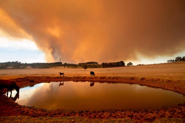
Residents across Cardinia impacted in the 2019 Bunyip Complex bushfire have contributed to new research highlighting the importance of bushfire maps, ensuring emergency information can be easily understood by communities under threat.
Conducted by Natural Hazards Research Australia, RMIT University, the Country Fire Authority, Emergency Management Victoria and the Victorian Department of Education, the ‘Predictions in public: understanding the design, communication and dissemination of predictive maps to the public’ study aimed to improve the design of maps which show a bushfire’s location and potential spread.
The research combined feedback from residents impacted in the 2019 Bunyip bushfire event, including Bunyip, Bunyip North, Maryknoll, Gembrook, Garfield, Garfield North, Nar Nar Goon and Tonimbuk.
A fire in the Bunyip State Park burned more than 15,000 hectares after several smaller fires merged, leading to the destruction of 29 homes around Bunyip North, Garfield North and Tonimbuk, as well as 67 outbuildings and sheds.
Presented to researchers and emergency service representatives at the 2024 Hazard Research Forum in Adelaide last week, the study showed the majority of Cardinia participants accessed maps via the VicEmergency app or the CFA website on their computer or their phone.
RMIT University senior research fellow Dr Erica Kuligowski said bushfire and hazard tracking maps were an essential tool for nearby residents so they are able to make the best proactive decisions for themselves and their families.
“When bushfire maps help people understand their location in relation to the bushfire risk, as well as other important information including direction of the fire spread and the location of the fire front, they are empowered to make the best protective action decisions for themselves and their loved ones,” she said.
“Participants indicated the importance of maps communicating the direction of fire spread, as well as locations of fire activity so that they can understand the uncertainty and immediate and subsequent risk, enabling them to make informed decision about when and how to avoid bushfire.”
The research found community members in areas of risk generally wanted bushfire maps to provide clear information to allow them to make safe decisions about when to evacuate, when to stay and defend and when to follow their household bushfire plan.
However, Dr Kuligowski said the study also highlighted the importance of timely and date-stamped information during times of extreme bushfire risk, with people accessing maps between 20 and 50 times a day during these times of severe danger.
“Participants found the inconsistencies between information sources due to different maps updating at different times confusing – especially when the time of last update wasn’t included,” she said.
“This made it extremely challenging for participants who experienced these fires to clearly understand the risk being faced and act safely in a rapidly changing situation.”
The use of fire predictions has received increasing attention since the 2019/2020 fire season when ‘red maps’ showing previously burnt areas were highlighted with red, with many believing these areas were still under risk or still burning.
Dr Kuligowski said the study also found participants were more likely to trust the maps if fire agency experts explained them in detail.
“Direct explanation of bushfire maps can improve residents’ understanding of and confidence in the information – helping reduce the possibility they will fill the gaps with their own knowledge and experience, which may not always lead to accurate conclusions,” she said.
“The meaning of warning polygons, the triangle symbols and the meaning of their location, and the risks associated with certain areas of maps – the burnt areas or the areas of potential fire spread – could be barriers to correct interpretation of bushfire maps.”
“We also found it was difficult for participants to identify the location of highest risk of harm, meaning additional work is required to ensure universal understanding of both incident and predictive maps.”
Dr Kuligowski said anyone in an area of high risk should be aware of multiple sources for information.
“It is important to note that any bushfire map is ‘one tool in the box’ for community members at risk – sourcing information from multiple sources, such as community meetings and official warnings, is critical to gaining as detailed an understanding of the risk as possible,” she said.
The project would now enter into the next phases, including developing principles for the standardised use of predictive maps within the Australian Warning System and developing practical outputs to ensure the results of the research were able to be utilised.
For more information on the project, visit www.naturalhazards.com.au/research/research-projects/predictions-public-understanding-design-communication-and-dissemination