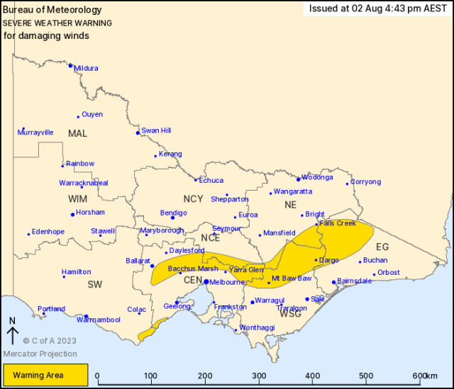
A severe weather warning has been issued by the Bureau of Meteorology for damaging winds on Wednesday 2 August at 4.43pm for people in parts North East Melbourne.
Strengthening northerly winds ahead of an approaching cold front are expected to result in damaging wind gusts about the central and northern ranges and the Otways and Surf Coast during Thursday. Winds are forecast to strengthen further during Friday with the passage of the front, easing during the afternoon.
Strong winds averaging 50 to 60 km/h with damaging wind gusts of around 90 km/h are possible over the central and northeast ranges and the Otways and Surf Coast from Thursday morning.
Winds are expected to abate for a period during Thursday evening, before redeveloping overnight with the passage of the cold front.
The winds may continue through into Friday afternoon as the front moves through to the east of the state.
Locations which may be affected include Apollo Bay, Dargo, Mt Baw Baw, Falls Creek, Mt Hotham and Omeo.
The State Emergency Service advises that people should:
* If driving conditions are dangerous, safely pull over away from trees, drains, low-lying areas and floodwater. Avoid travel if possible.
* Stay safe by avoiding dangerous hazards, such as floodwater, mud, debris, damaged roads and fallen trees.
* Be aware – heat, fire or recent storms may make trees unstable and more likely to fall when it’s windy or wet.
* Check that loose items, such as outdoor settings, umbrellas and trampolines are safely secured. Move vehicles under cover or away from trees.
* Stay indoors and away from windows.
* If outdoors, move to a safe place indoors. Stay away from trees, drains, gutters, creeks and waterways.
* Stay away from fallen powerlines – always assume they are live.
* Be aware that in fire affected areas, rainfall run-off into waterways may contain debris such as ash, soil, trees and rocks. Heavy rainfall may also increase the potential for landslides and debris across roads.
* Stay informed: Monitor weather warnings, forecasts and river levels at the Bureau of Meteorology website, and warnings through VicEmergency website/app/hotline.